WATERWAYS 

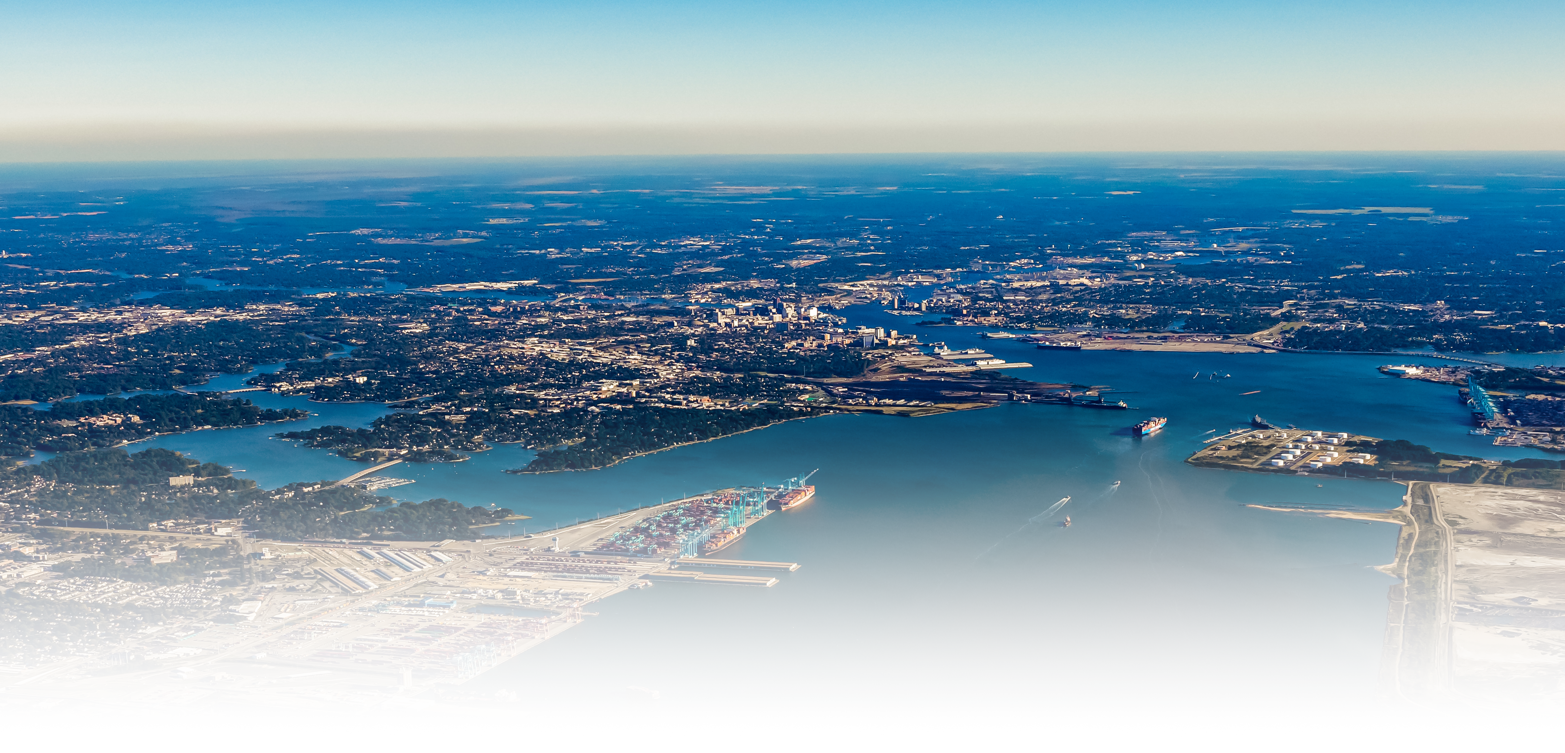
Virginia’s waterways are essential to maritime commerce, connecting Chesapeake Bay to major ports and inland destinations. The Atlantic Ocean Channel and Thimble Shoal Channel provide deep-water access for global shipping. At the heart of Virginia’s maritime infrastructure lies Hampton Roads Harbor, a naturally deep and ice-free harbor formed by the James, Nansemond, and Elizabeth Rivers, providing seamless access to the state's primary ports. Key routes like the Norfolk Harbor Channel, Newport News Channel, and James River Channel support cargo movement to major terminals and inland ports. Ongoing projects, including the Craney Island Expansion and Norfolk Harbor deepening, ensure Virginia’s ports remain competitive and accessible for larger vessels.

Key Waterways:

Extends from the mouth of the Chesapeake Bay out into the deep water of the Atlantic Ocean. The Atlantic Ocean Channel, which has a length of 11.1 miles, was dredged to a depth of 52-feet and a width of 1,300-feet in 2006. Authorized improvements for the Atlantic Ocean Channel provide for deepening to 57-feet, with follow-up designs recommending a need for deepening to 60-feet.  

Extends from the Virginia Capes across the lower end of the Chesapeake Bay into the deep waters of Hampton Roads. Thimble Shoal Channel is presently 1,000-feet wide and approximately 13 miles long. In 1988, the 650-foot wide outbound lane of the 45-foot channel was deepened to 50-feet. The remaining 350-foot wide inbound side of the 45-foot channel was deepened to 50-feet in 2003.

 Two channels extend through Hampton Roads – one southward into Norfolk, Portsmouth and Chesapeake and one westward to Newport News and up the James River. Authorized improvements for Thimble Shoal Channel provide for deepening to 55-feet. 

Located midway on the Atlantic Coast of the United States, in latitude 37 degrees north and longitude 76 degrees west, Hampton Roads is free of ice throughout the year. The broad, magnificent Hampton Roads Harbor is formed by the con fluence of three 
tidal rivers: the James, the Nansemond, and the Elizabeth. It has an area of 35 square miles and forms the approach to the important deep draft ports of Norfolk, Newport News, Ports mouth, and Chesapeake. Ships entering Hampton Roads from the sea follow a course between the Virginia Capes, across the lower end of Chesapeake Bay via Thimble Shoal Channel into the deep waters of Hampton Roads. 

Extends from Hampton Roads into the Southside cities via the Elizabeth River into Norfolk, Portsmouth and Chesapeake. Beginning at the Hampton Roads Bridge Tunnel, and extending to a 0.8 mile above the Interstate 64 Bridge, the Norfolk Channel is 19.6 miles long. With the deepening of the outbound lane in 1988, and the deepening of the inbound lane in 2005, a 1,250-foot wide channel providing access from deep water in Hampton Roads to the Norfolk International Terminals, and an 800-foot wide channel extending upstream providing access to the Norfolk Southern coal piers at Lambert’s Point, is currently maintained to a depth of 50-feet. A 40-foot channel extends from the coal piers to the Norfolk Southern Railway Bridge on the Southern Branch. Beyond this point a 35-foot channel extends 4.6 miles to a point 0.8 mile above the Interstate 64 Bridge, where the channel connects with the Atlantic Intracoastal Waterway route through the sounds of North Carolina to the South Atlantic Coastal states. 

The width of the Norfolk Harbor Channel, when including the 45-foot deep and 250-foot wide auxiliary channel to the east, is 1,500-feet from its outer end to a point opposite Norfolk International Terminals; then 800-feet wide to the Norfolk Southern Railway coal piers; thence, 750-feet wide to the junction of the Eastern and Southern Branches; thence, up the Southern Branch 450-feet wide to the Belt Line Railroad Bridge; thence, 375-feet wide for one mile to the Norfolk Southern Railway Bridge; thence, 250 to 500-feet wide to its junction with the Atlantic Intracoastal Waterway route.

Authorized improvements provided for deepening the Norfolk Harbor channel to 55-feet between Hampton Roads Bridge Tunnel and Lambert’s Point; deepening the main stem of the Elizabeth River and the Southern Branch of the Elizabeth River between Lambert’s Point and the Norfolk Southern Railway Bridge to 45-feet; deepening the Southern Branch between the Southern Railway Bridge and the U.S. Routes 460 and 13 highway crossing to 40-feet; and providing a new 800-foot turning basin at the terminus of the channel improvement.

Extends 6.7 miles westward from Hampton Roads to Newport News. The Channel to Newport News has a depth of 50-feet over a width of 800-feet. Authorized improvements for the Newport News Channel provide for deepening to 55-feet. 

Extends 68 and 90 miles respectively to the ports of Hopewell and Richmond, with a depth of 25-feet to Hopewell, 25-feet to Richmond Deepwater Terminal, and 18-feet to Richmond Harbor. The maintained channel width is 300-feet to Hopewell and 200-feet from Hopewell to Richmond Harbor. 

The Eastern Branch of the Elizabeth River includes a channel 25 -feet deep and 500-feet wide from the junction of the branches to the Norfolk Southern Railroad Bridge, from the Norfolk Southern Railroad Bridge a channel 25-feet deep and 300-feet wide to the Campostella Bridge, thence a channel 25-feet deep and 200-feet wide to the Norfolk Southern Railroad Bridge, including a turning basin 25-feet deep and approximately 55-acres in size located at the upstream end of the project. 

The Southern Branch of the Elizabeth River includes a channel 45-feet deep and 450-feet wide from the junction with the Eastern Branch to the N.& P.B.L. Railroad Bridge; thence 45-feet deep and 375-feet wide to the Norfolk Southern Railroad Bridge; thence 40-feet deep and 250-feet to 500-feet wide to the U. S. Routes 460 and 13 Highway bridge; thence 35-feet deep and 250-feet to 300-feet wide to a point 0.8 miles above Interstate 64 high level bridge. Project includes an approach and turning basin 45-feet deep opposite the Norfolk Naval Shipyard; a turning basin at the mouth of St. Julians Creek 40-feet deep, 400 to 600-feet long, and 800-feet wide; a turning basin at the mouth of Milldam Creek 40-feet deep and 800-feet square; and a turning basin at the mouth of Mains Creek, the upstream end of the project, 35-feet deep and 800-feet square.  

The 2018 Validation Report details the improvements being considered during the Pre-Construction Engineering and Design phase. The improvements being considered for the Southern Branch of the Elizabeth River include the deepening of the 40 ft channel from Lamberts Bend to the Perdue Terminal to 45 ft; the deepening of the 40 ft channel from the Perdue Terminal to the Norfolk Southern Lift Bridge to 42 ft; the deepening of the 35ft channel from the Lift Bridge to the Gilmerton Bridge to 39 ft; and the continued maintenance of the existing 35-foot-deep channel from the Gilmerton Bridge to the Chesapeake Extension.